adapted from
Historical sketch of the rebellion
Contributor Names: Lindenkohl, H. (Henry)
Created / Published: [S.l.], Office of the U.S. Coast Survey, [1864]
Subject Headings
 -United States--History--Civil War, 1861-1865 -United States--History--Civil War, 1861-1865
-United States
Notes
-Scale 1:5,850,000.
-LC Civil War Maps (2nd ed.), 49
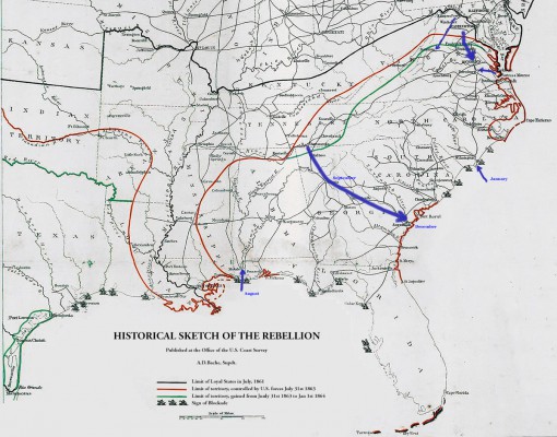
-"Limit of loyal states in July, 1861, limit of territory
controlled by U.S. forces July 31st 1863, [and] limit of territory
gained from July 31st 1863 to Jan. 1st 1864" indicated by colored
lines. Small ships denote the extent of the naval blockade.
-"Population census 1860" in the lower right corner.
-See also Civil War Maps entry nos. 34, 35, 36, 39, 40 and 40.1.
-Another copy is in the James A. Garfield papers, Manuscript
Division, L.C., series 8, container no. 1.
-Description derived from published bibliography.
-Available also through the Library of Congress web site as raster image.
Medium
1 map, col., 47 x 45 cm.
Call Number
G3701.S5 1863 .L5
Repository
Library of Congress Geography and Map Division Washington, D.C. 20540-4650
Digital Id
g3701s cw0049000 http://hdl.loc.gov/loc.gmd/g3701s.cw0049000
Library of Congress Catalog Number
99447147
http://lccn.loc.gov/99447147
|
|
 chapter 6